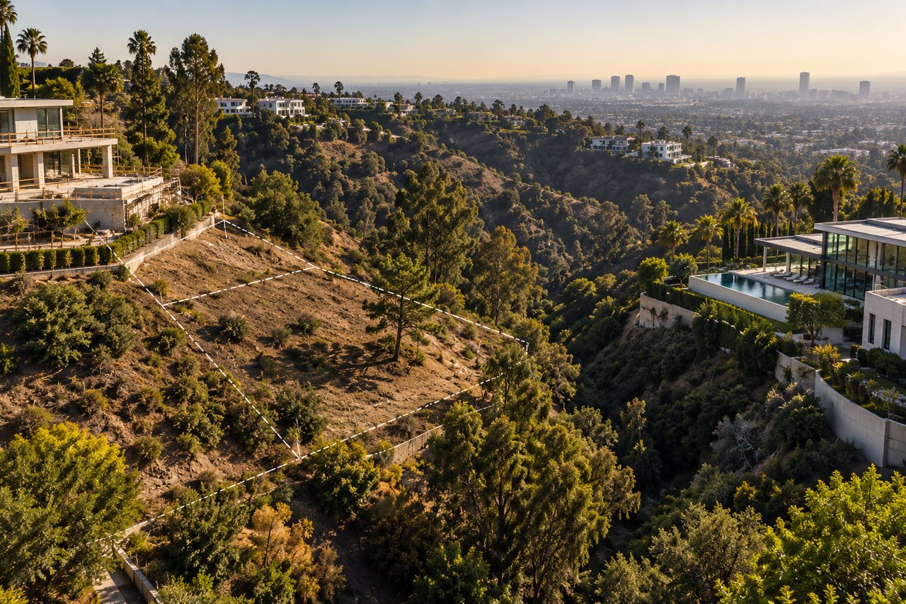
Some of the most coveted canyon lots in Los Angeles carry premium price tags and yet sit empty year after year. Bel Air setback requirements are often the quiet reason why. Luxury real estate transactions in these areas demand far more than a review of standard zoning; they require a clear understanding of regulatory layers that stack on top of one another in ways that are rarely obvious at first glance. On hillside parcels, setback rules tied to fire access, utility easements, and slope restrictions can overlap and compound, leaving far less usable land than the parcel size suggests.
For buyers who value precision in high-stakes property decisions, this article examines how to identify true buildable area before acquisition, what survey documents actually reveal, and how to approach constrained sites with clarity rather than costly surprises.
Understanding Bel Air's Layered Setback System
Setbacks are mandated buffer zones between structures and property boundaries areas where construction cannot occur even when the land is fully owned. What makes Bel Air particularly complex is that these restrictions don't arrive as a single rule. They arrive in layers, each one trimming the buildable area of canyon parcels further than the last.
Base Zoning District Requirements
Los Angeles zoning classifications establish the starting point, setting minimum setbacks for front, side, and rear yards across Bel Air properties. Low-density residential zones carry the strictest requirements — a standard lot might face a 30-foot front setback, 10-foot side setbacks, and a 20-foot rear setback. On a 100-by-150-foot parcel, that alone removes a meaningful portion of the land before any other regulation enters the picture.
Measurements run from property lines inward, blocking construction from ground to sky within those zones. There are minor exceptions: bay windows may project up to two feet into required setbacks, eaves up to two and a half feet, and open porches or carports may extend eight feet into front setbacks and five feet into rear setbacks. These allowances exist, but they offer limited relief within otherwise firm boundaries.
Hillside Overlay Restrictions
Nearly all of Bel Air falls under the Baseline Hillside Ordinance, given the neighborhood's steep terrain above Sunset Boulevard. This overlay introduces its own set of rules floor area limits, height restrictions, and grading standards that run parallel to, not in place of, base zoning setbacks.
Before permits are issued, the Los Angeles Department of Building and Safety's Geology & Soils Engineering Section requires geotechnical reports covering slope stability and foundation design. These reports frequently flag setback zones where building would compromise the hillside itself, pushing required buffers well beyond what base zoning alone demands.
Fire Department Access Setbacks
Bel Air's streets are often narrow and served by a single point of access — conditions that trigger Los Angeles Fire Department requirements functioning as a de facto setback. Streets under 26 feet wide call for additional on-site parking positioned away from driveway aprons, which absorbs front yard area that might otherwise be buildable. Fire apparatus access roads must hold a clear width of 20 feet, and security gates cannot narrow that corridor.
Properties within Very High Fire Hazard Severity Zones carry an additional layer: defensible space requirements enforced by the LA Fire Department Brush Clearance Unit. Mandatory vegetation clearance around structures produces buffer zones that, while not labeled as zoning setbacks, function precisely the same way when determining where a building can actually sit.
Utility and Drainage Easement Setbacks
Utility easements typically run at least 20 feet wide, centered along rear or side lot lines — roughly 10 feet on either side of a property boundary. Ownership of the land within these zones remains with the property owner, but structures that would interfere with utility access are prohibited. Drainage easements add another 12.5 feet from watercourse lines where construction and maintenance must remain accessible.
Fences, walls, and retaining structures are all prohibited within drainage easements. The easement holder holds the right to remove obstructions or disturb landscaping without any compensation owed to the property owner. Technically, these zones don't carry the label of zoning setbacks practically, they behave exactly the same.
How Multiple Rules Compound on Canyon Lots
The critical point is that each of these layers operates independently. A canyon lot might surrender 30 feet to front setbacks, 10 feet per side to base zoning, 20 feet to rear setbacks, 10 more feet to utility easements, and further area to slope stability buffers. A parcel that reads as half an acre on paper may yield only a quarter-acre of land where construction is actually permitted. Should geotechnical reports flag additional slope concerns, or fire access rules demand wider clearances, the combined effect can make a parcel effectively unbuildable — not because it violates any one rule, but because it answers to all of them at once.
The Hidden Triggers That Make Lots Unbuildable
Layered setback rules are only part of the story. Several specific conditions within Bel Air setback requirements can push a lot from technically compliant to functionally unbuildable and these triggers emerge not from the restrictions themselves, but from what sits within the mandated buffer zones.
Inadequate Street Frontage After Setbacks
Street frontage determines whether a parcel can realistically support construction once setbacks have done their work. When frontage proves too narrow for minimum width requirements in a given zoning district, the lot effectively loses its buildability — not through any single dramatic rule, but through the quiet math of reduced space. Road access compounds the issue; without sufficient frontage or an obtainable easement providing right-of-way, construction cannot proceed. Lots that read as buildable on a title report can become unusable once front setbacks extend deeper than anticipated, leaving no room for required parking, turnarounds, or structural footprints that satisfy code minimums.
Slope Percentage in Required Setback Zones
Slope stability analysis underpins every hillside development decision. The factor of safety calculation weighs resisting forces against driving forces, with the International Building Code requiring a minimum factor of 1.5 for static conditions on permanent slopes. Seismic conditions call for a factor of 1.25. What seems like a small numerical gap carries real consequences on the ground. A factor of 1.5 versus 1.3 can mean the difference between a 2:1 slope and a 3:1 slope — and on a 30-foot cut, that translates to 15 additional horizontal feet consumed, either as lost buildable area or as the footprint of expensive retaining walls.
Code requires buildings to sit back from slope tops by one-third to one-half the slope height, with minimums ranging from 5 to 15 feet depending on jurisdiction. That zone cannot be used for building footprints. Structures at slope bases face setbacks of one-half the slope height, capped at 15 feet. Where slopes exceed certain thresholds, foundations must be deepened and positioned away from slope faces. On parcels with a 100-foot setback requirement measured perpendicular to ridge lines, the lot can become unbuildable outright unless lesser setbacks are demonstrated to be feasible.
Protected Tree Locations Within Setbacks
Los Angeles has protected native trees since 1982 under the Native Oak Protection Ordinance. The Protected Tree and Shrub Ordinance expanded that coverage in December 2020, adding Mexican Elderberry and Toyon to the list. When development is proposed on properties with protected species, additional review layers apply. The practical result: setback zones that already restrict construction can contain trees that cannot be removed, closing off space that might otherwise remain usable. Where protected vegetation occupies a critical position within a front, side, or rear setback, the ordinance adds a layer of complexity that no amount of variance negotiation easily resolves.
Geotechnical Stability Buffers
Geotechnical investigations require subsurface exploration that reaches below the deepest potential failure surface — often 20 to 50 feet or more below slope faces. The resulting reports deliver setback distance recommendations from slope crests and toes, maximum cut and fill angles, and required stabilization measures. Where groundwater seepage is present, buildings cannot be placed within setback zones until subdrains with perforated pipe are installed to bring water tables down. These geotechnical buffers routinely exceed base zoning setbacks, and when stability concerns consume what little buildable space remains after other restrictions have applied, the lot's development potential can disappear entirely.
Reading Surveys and Title Reports for Setback Issues
"A title search reviews documents. A survey verifies the land itself." — McSteen, Licensed Professional Surveyors
A title report tells part of the story. An ALTA survey tells the rest. Established by the American Land Title Association and the National Society of Professional Surveyors, ALTA surveys represent the highest survey standards in the industry — going well beyond property lines to examine improvements, easements, and risks that public records may never surface.
What an ALTA survey reveals about buildable area
Where a title report reviews documents, an ALTA survey compares those documents against actual site conditions. Recorded easements, shared access routes, utility areas, encroachments, and conflicts between paperwork and physical reality all come to light. Critically, the survey identifies setback requirements under local zoning ordinance. When improvements sit closer to property lines than the ordinance allows, the owner has a setback violation — one that may require a variance or, in serious cases, removal of the offending structure.
Lenders look for exactly this before funding acquisitions. The survey documents boundary lines with bearings and distances, all site improvements, on- and off-property encroachments, easements from title commitments, rights-of-way, and any discrepancies between recorded and actual conditions. Buyers who skip this step often discover restrictions only after architects or contractors begin planning — at which point redesign costs climb quickly.
Interpreting recorded easements and their impact
Utility easements restrict what owners can build, pave, or install on their own property. Structures placed within easement areas carry real risk: utility companies hold legal rights to remove them for maintenance or repairs, with no compensation owed to the property owner. The easement holder's access rights take precedence, and the property owner absorbs the full cost when utilities must tear up landscaping or remove structures to reach infrastructure.
Access easements carry their own complications, allowing neighboring properties to legally cross part of a parcel and affecting traffic flow, parking design, deliveries, and future redevelopment plans. Drainage easements mandate preserved flow paths or outright no-build zones. Each easement's precise location and dimensions — defined by bearings, distances, coordinates, or reference to recorded maps — must be read carefully on deeds, surveys, or plats.
Identifying non-conforming setback situations
Some structures predate current code entirely. Nonconforming buildings were lawfully erected under older standards that no longer apply to setbacks, height, stories, lot coverage, or floor-area ratio. Alterations are permitted as long as nonconforming dimensions are not increased — a nonconforming wall cannot be raised or widened without variance approval, and walls cannot be added to carports within setbacks without going through the same process.
Spotting potential encroachments on neighboring lots
Encroachments are easy to miss and expensive to resolve. The term covers any improvement or physical feature that crosses a property line — whether the subject property extends onto adjacent parcels or a neighbor's structure reaches onto the subject. It also applies to structures that protrude over setback restriction lines. Fences and walls shift and settle over time, quietly altering their relationship to boundary lines. Bay windows, cantilevered roof overhangs, and additions can push past boundary or setback lines without the owner's awareness. Survey plats must display dimensions sufficient to show each feature's precise relationship to boundary lines — and a thorough review of those plats is what separates an informed buyer from one who inherits someone else's problem.
Case Examples: Lots That Stayed Empty and Why
"Most people look at a piece of land and only see what’s sitting on it. Developers look at the same land and see what the city might allow it to become." — Kiran Kaur, Developer
Real parcels tell the clearest story of how Bel Air setback requirements compound into unbuildable situations — often on land that looked, at first, entirely promising.
Canyon parcel with overlapping easements
A two-acre Northern California property listed at $450,000 offers a precise illustration of how easements quietly eliminate buildable space. The 87,120-square-foot lot carried three recorded easements: a 20-foot utility easement along the full street frontage consuming 1,740 square feet, a 30-foot drainage easement cutting through the property's center and removing 2,610 square feet, and a 15-foot access easement for neighboring properties accounting for another 1,305 square feet. Total easement area reached 5,655 square feet — before a single setback line was drawn.
Once standard setbacks of 25 feet front, 10 feet per side, and 20 feet rear were applied, the property shed an additional 21,780 square feet. Net buildable area fell to 59,685 square feet from the original 87,120. The jurisdiction's floor area ratio calculations further subtracted easements from lot size, reducing the maximum allowable home size from 21,780 square feet to 20,366 square feet — a loss of 1,414 square feet. The buyers, once these constraints came to light, negotiated a $50,000 price reduction.
Hillside lot with inadequate rear setback
Slope geometry creates its own form of setback. Foundations near slope tops require buffer distances equal to one-half the slope height, capped at 15 feet. Structures at slope bases must sit back one-third of that height, with a 40-foot maximum. When these geotechnical buffers exceed what base zoning already demands — which they frequently do — the remaining usable footprint can disappear entirely.
Historic subdivision with pre-code setbacks
Not every unbuildable lot traces its limitations to geography. Older subdivision plats often created parcels that no longer meet current minimum area and width requirements. Owners of these lots can find themselves denied permits despite years of paying property taxes on land that appeared, on paper, fully entitled. Without nonconformity protections in place, the gap between assessed value and actual development potential can be significant.
Working with Setback Constraints Strategically
Knowing the risks is only half the work. What separates buyers who close confidently on constrained parcels from those who walk away with losses is what they do — and when they do it — during due diligence.
Engage a Land Use Attorney Early in Due Diligence
Before closing any real estate deal, buyers should have a clear picture of every restriction the law places on how land can be used. Zoning laws, environmental regulations, and site-specific constraints can each affect development potential in ways that aren't obvious from a title report alone. A land use attorney identifies these issues early, guides clients through the permitting process, and helps ensure that every applicable regulation is accounted for before money changes hands.
Commission a Preliminary Site Plan Before Close
A preliminary site plan approval confirms that a project's general layout meets planning requirements before detailed engineering begins. This step — handled by the Planning & Zoning Commission — gives buyers real answers about what can actually be built on a property. Fees are typically modest, around $500 plus $50 per acre once the application is complete, and the information gained is worth far more.
Explore Variance Feasibility with City Planners
Variances exist for situations where unique physical conditions on a property make strict code compliance a genuine hardship. A pre-application meeting with planning staff can reveal early on whether a variance is realistic, what the agency will likely require, and whether a proposed project has a viable path forward. This conversation costs very little and can save a great deal.
Consider Holding Costs if Entitlement is Uncertain
When approvals are not guaranteed, making the purchase contingent on securing them is a straightforward way to protect against acquiring land that cannot be developed. Experienced buyers structure their offers accordingly rather than absorbing the full risk at close.
Partner with Architects Experienced in Constrained Sites
Hillside sites with complex restrictions often carry real advantages: lower acquisition costs, exceptional views, and a level of natural privacy that flat parcels simply cannot offer. Architects who specialize in difficult terrain understand how to work with the land rather than against it — and that distinction shows in the finished home.
For those who love to entertain and want a home that reflects both lifestyle and investment sensibility, finding the right property takes the right guidance. If you are beginning your search or considering a purchase in the near future, Christina Pope would be delighted to help.
Christina Pope 📞 310-404-9931 ✉️ [email protected]
Conclusion
Bel Air's canyon lots reward those who arrive prepared. The regulatory layers — base zoning, hillside overlays, fire access rules, utility easements — rarely announce themselves clearly, and they do not wait to be discovered after escrow closes. The most premium parcels in this market tend to carry the most complex constraints, which is precisely why the due diligence process matters as much as the property itself.
Certainty comes from commissioning an ALTA survey, securing geotechnical review, and engaging land use counsel well before acquisition — not after an architect uncovers what the title report missed. Buyers who calculate buildable area independently, rather than relying on estimates, are the ones who turn constrained hillside parcels into genuine opportunities.
For those considering a purchase in Bel Air or the surrounding canyon communities, Christina Pope brings the kind of market knowledge and careful attention that these decisions require. Christina Pope 📞 310-404-9931 ✉️ [email protected]
Key Takeaways
Bel Air's canyon lots face multiple overlapping setback requirements—base zoning, hillside overlays, fire access rules, and utility easements—that can compound to consume over 50% of a parcel's buildable area, leaving some lots functionally unbuildable despite premium valuations.
• Commission an ALTA survey and preliminary site plan during escrow, not after purchase—hidden easements, slope stability buffers, and protected trees within setback zones frequently eliminate buildable space that title reports don't reveal.
• Engage land use attorneys and geotechnical engineers before closing to calculate actual buildable area independently—what appears as a half-acre parcel may offer only a quarter-acre of usable space after all restrictions compound.
• Properties with inadequate street frontage after setbacks, slopes requiring stability buffers exceeding 15 feet, or utility easements overlapping drainage zones often become unbuildable despite conforming to any single regulation independently.
• Strategic buyers make purchases contingent on securing approvals and partner with architects experienced in constrained hillside sites—the most valuable lots demand the deepest due diligence precisely because their premium positioning attracts the strictest regulatory overlays.
FAQs
Q1. What makes some Bel Air canyon lots unbuildable despite being legally owned? Multiple setback requirements layer on top of each other—base zoning rules, hillside overlays, fire department access requirements, and utility easements can combine to consume over 50% of a lot's area. When these restrictions overlap with slope stability concerns or protected trees, they can eliminate all practical building space even though the owner holds clear title to the land.
Q2. How do I determine the actual buildable area of a hillside lot before purchasing? Commission an ALTA survey and preliminary site plan during your due diligence period. These documents reveal recorded easements, geotechnical stability buffers, and the precise relationship between property boundaries and setback lines. Calculate buildable area independently rather than relying on title company estimates, as what appears as a half-acre parcel may offer only a quarter-acre of usable construction space after all restrictions apply.
Q3. What role do utility easements play in reducing buildable space? Utility easements typically span at least 20 feet and prohibit any structures that interfere with access to infrastructure. Property owners retain land ownership but cannot build within these zones, and utility companies can remove improvements without compensation if maintenance requires it. When combined with drainage easements and standard setbacks, these restrictions effectively function as unbuildable zones that significantly reduce available construction area.
Q4. Can I get a variance if my lot doesn't meet current setback requirements? Variances are possible when unique property conditions create hardship, but they require demonstrating that the land's physical characteristics—not financial considerations—prevent reasonable use. Schedule pre-application meetings with city planning staff to assess feasibility before purchasing. Many experienced buyers make their land purchases contingent on securing necessary approvals to avoid spending acquisition costs on lots that ultimately cannot be developed.
Q5. Why should I hire specialized professionals for hillside lot purchases? Land use attorneys identify zoning restrictions and environmental regulations during due diligence, while geotechnical engineers assess slope stability and required buffer zones that often exceed base setback requirements. Architects experienced with constrained sites understand how to maximize buildable area within complex regulatory frameworks. These professionals help calculate actual development potential before closing, preventing costly discoveries after purchase when redesign options become limited and expensive.